

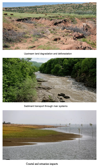
Bangladesh is a delta country, shaped continuously by the enormous
sediment loads carried by the Padma, Brahmaputra-Jamuna and Meghna river
systems into the Bay of Bengal. Every year, vast quantities of sediment are
transported downstream and deposited across the delta, estuaries and coastal
areas. This process of sediment deposition and coastal accretion
contributes to the formation and expansion of new land, particularly in the
form of chars and intertidal areas.
So, does new land formation contribute to sea-level rise?
No. Quite the opposite. Sediment deposition does not cause global
sea-level rise. Global mean sea level is rising primarily because of thermal
expansion of seawater and the melting of glaciers and ice sheets. In a delta
such as Bangladesh, however, the continuous delivery and deposition of sediment
can help raise the elevation of parts of the land surface and allow some
coastal areas to maintain their elevation relative to the rising sea.
This natural process is therefore an important component of Bangladesh's
long-term resilience to sea-level rise. However, it should not be misunderstood
as a guarantee against coastal inundation. Where land subsidence, erosion,
sea-level rise, storm surges and reduced sediment supply exceed the rate of
natural sediment accumulation, coastal vulnerability can increase
significantly.
This leads to an important question: if sediment is so important for
maintaining the delta, why does sedimentation also contribute to serious
flooding problems?
The answer lies largely in where the sediment comes from, where it is
deposited, and how the river system is managed.
The Hilly Area Crisis: Deforestation, Soil Erosion and Rising Riverbeds
The problem begins
far upstream.
Deforestation, uncontrolled hill cutting, poorly planned infrastructure
development and inappropriate land-use practices in hilly areas including parts
of the Chittagong Hill Tracts and Cox's Bazar, as well as upstream areas of the
wider Ganges-Brahmaputra-Meghna basin can accelerate soil erosion.
During intense monsoon rainfall, exposed and unstable slopes release
large quantities of sediment into streams and rivers. Once this material enters
the river network, some of it is transported downstream while another portion
settles within river channels, floodplains and estuarine areas.
Excessive sediment deposition in strategically important river channels
can reduce channel capacity and alter river morphology. In combination with
high monsoon flows, inadequate drainage and riverbank instability, this can
increase the risk of flooding, channel shifting and riverbank erosion.
The situation is particularly complex in Bangladesh because the country
receives water and sediment from one of the world's largest transboundary river
systems. Bangladesh is effectively located at the downstream end of the basin,
meaning that processes occurring hundreds or even thousands of kilometers
upstream can ultimately affect its rivers, floodplains and coastal areas.
The Core Question: Can Coastal Plantation Alone Solve the Problem?
No. Coastal plantation is extremely important, but it should not
be considered a complete solution to Bangladesh's broader hydrological and
sediment-management challenges.
A coastal plantation
is essentially a localized natural defense system. It can stabilize
newly deposited land, reduce wind and wave energy, protect communities from
storm impacts and provide important ecological services. But it cannot address
the causes of excessive sediment generation or hydrological problems
originating upstream.
Why Coastal Plantation Remains Essential
Recognizing its limitations does not mean reducing the importance of
coastal afforestation. On the contrary, coastal plantation should remain a
central component of Bangladesh's climate adaptation and coastal resilience
strategy.
1. Stabilizing Newly Formed Land
Newly formed chars and coastal sediment deposits are often highly
unstable. Strong tides, waves, river currents and cyclonic events can rapidly
erode these deposits.
Mangroves and other suitable coastal vegetation can function as a form of
biological engineering. Their root systems bind and trap sediment,
reduce surface erosion and promote sediment accumulation. Over time, vegetation
can help stabilize newly accreted land and create conditions that support
ecological succession and, where appropriate, future human use.
Thus, coastal plantation is not merely about planting trees, it is about helping
the delta stabilize itself.
2. Protection from Cyclones and Storm Surges
Bangladesh's coastal communities face recurrent cyclones, storm surges,
high winds and coastal flooding. Dense belts of suitable coastal vegetation can
reduce wind velocity, attenuate wave energy and trap sediment. Mangrove forests
can provide a valuable buffer between coastal communities and the sea.
Of course, forests cannot eliminate the effects of a major cyclone or
storm surge. Their effectiveness depends on factors such as forest width,
species composition, vegetation density, topography and the characteristics of
the incoming storm. Nevertheless, healthy coastal forests can significantly
strengthen the nature-based defense system of vulnerable coastal
communities.
3. Biodiversity and Ecosystem Services
Coastal plantations also provide benefits beyond physical protection.
They can create habitat for fish, birds, reptiles and other wildlife; support
fisheries; store carbon; improve ecological connectivity; and provide
livelihood opportunities for coastal communities. Therefore, coastal
afforestation should be viewed as an ecosystem-based adaptation measure,
rather than simply as a tree-planting programme.
Why We Must Look Beyond Coastal Plantation
The central lesson is that Bangladesh's coastal problems cannot be solved
at the coast alone.
A river is a connected system. What happens in the upper catchment can
influence the middle reaches, floodplains, estuaries and ultimately the coast. Therefore,
Bangladesh needs an integrated ridge-to-river-to-coast approach to
environmental and hydrological management.
Three broad interventions deserve particular attention.
1. Stronger Upstream Forest and
Catchment Conservation
Preventing excessive soil erosion at its source is far more effective
than attempting to manage all the sediment after it has entered the river
system.
This requires:
- Strict control
of illegal hill cutting and deforestation;
- Restoration of
degraded hill forests;
- Sustainable
land-use practices in erosion-prone areas;
- Proper
environmental assessment of infrastructure development;
- Stabilization
of vulnerable slopes;
- Protection and
restoration of riparian vegetation; and
- Catchment-based
soil and water conservation.
The objective should not simply be to keep sediment out of rivers. Sediment
is essential to delta formation. The objective should be to manage sediment
so that it reaches and nourishes the delta without causing unacceptable damage
to river channels, floodplains and infrastructure.
2. Strategic River Management and
Dredging
Dredging can be an important component of river management, particularly
where excessive deposition creates navigation problems, drainage congestion or
localized reductions in channel capacity. However, dredging should not be
regarded as a universal or permanent solution to flooding.
Unplanned or continuous dredging can be extremely costly and may have
unintended ecological and geomorphological consequences. River channels are
dynamic systems, and sediment removed from one location may be replaced by
sediment transported from elsewhere.
In appropriate locations, dredged sediment could potentially be used for land
elevation, restoration of degraded areas and climate-resilient infrastructure, subject
to environmental safeguards. The goal should be strategic sediment
management, rather than simply “dredging more.”
3. Regional Hydro-Politics and Transboundary Cooperation
Bangladesh cannot manage the Ganges-Brahmaputra-Meghna basin
independently. Water and sediment do not recognize national boundaries.
Decisions taken in upstream countries can affect downstream hydrology, sediment
transport, flooding, erosion and coastal processes. Consequently, Bangladesh
needs stronger scientific and institutional cooperation with India, Nepal,
Bhutan and China.
Bangladesh's geographical position at the downstream end of the basin
makes regional cooperation not merely desirable, but strategically important
The Way Forward:
From Tree Planting to Delta Management
Conclusion: The Double-Edged Nature of
Sediment. Bangladesh's sediment is both a blessing and a challenge.
The same sediment that creates new land and helps sustain the delta can,
under certain circumstances, contribute to riverbed aggradation, channel
instability, drainage congestion and flooding. Similarly, the same river system
that nourishes the coast can also threaten communities through erosion and
extreme floods. Therefore, the
answer is not to stop sediment from reaching Bangladesh's coast. Nor is it
realistic to depend solely on dredging or coastal plantation. The objective should be to manage the entire
sediment and water system intelligently from the hills to the rivers, from the
floodplains to the estuaries, and finally to the coast. Coastal plantations
should be highly valued for stabilizing newly formed land, protecting coastal
communities, conserving biodiversity and strengthening Bangladesh's natural
defense against cyclones and storm surges. But we should not expect coastal forests
alone to solve problems generated throughout the river basin.
If we want to protect Bangladesh's coast, we must begin much farther
upstream. The future of Bangladesh's coastal resilience will depend not simply
on how many trees we plant at the coast, but on how wisely we manage the entire
delta system.
Share this page via
More from Dr. Mohammad Zahirul Haque